- ITENERY
- PAYMENTMETHOD
- INCLUSION & EXCLUTION
- NOTE
- Day 1: Reaching Base Camp – Auli Trek Itinerary
Auli is 214 km from Haridwar. Arrive at Haridwar the previous night or early morning by 6:00 am (on your own). We will organize pick-up vehicles from Haridwar railway station at 6:30am. The pickup will be arranged in a Bolero or Tempo Traveller (12 seater). The cost of transit from Haridwar to Auli will have to be borne by the trekkers. The total cost of transportation (one way) Haridwar to Auli is Rs 5,800 (Bolero), Rs 9,000 ( Tempo Traveller) (to be shared among the trekkers). The journey to Auli is approximately 11 hours. You will reach Auli around 5.30 pm. Stay overnight in tents.
- Day 2: Auli to Padiyar Camp
- Altitude: 8,800 ft to 10,500 ft
- Time taken: 3.5 – 4 hours
- Trek gradient: Moderate
- Water sources: You can refill your water bottles from the hotels at Towers 8 and 10 of the ropeway, the latter being around mid way through the day’s trek
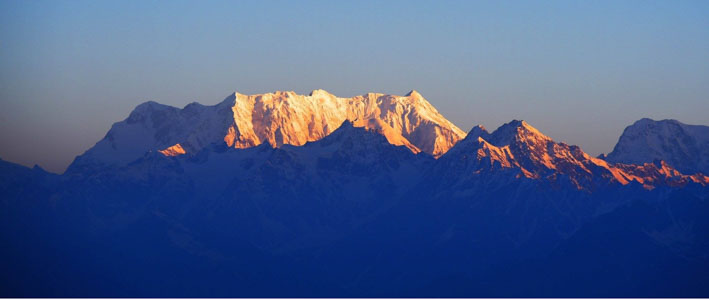
The trek begins at Auli which is famous for its ski slopes. Auli also gives outstanding views of India’s highest summit Mt. Nanda Devi. The trail starts right at the Auli ski lift. Its a straight ascent as you pass the ski slope, the Cliff top Resort and further.
The 2,000 ft climb through Auli slope will take about 2.5 hours. The end of Auli brings you to a magical Oak forest. The Oak trees grow into the sky and the ground is strewn with fallen leaves. A beautiful trail winds through the trees climbing gently. About an hour into the forest you come to a small shrine. The camp for the day is not far from here. There are a couple of small streams near by. If you are mesmerized by the Oak forest, there is more to come. The forest opens into Gorson Bugyal – a far stretching high altitude meadow with high peaks towering from all around.
The early end of the trek is for two reasons. One is acclimatization. You have already climbed 2500 ft and it is imperative that you don’t climb any further for natural acclimatization. Second, you are almost at the edge of Gorson Bugyal. Experiencing Bugyal with its mountains in the evening sun is an experience in itself. The campsite at the fringe of Gorson Bugyal gives you lot of time to explore the Bugyal and experience the mountains for the rest of the day.
- Day 3: Padiyar Camp to Tali
- Altitude: 10,500 ft to 11,000 ft
- Time taken: 4.5 hours
- Trek gradient: Moderate
- Water sources: Carry 2 litres of water from Padiyar since there is no water source on the trail today.
The days trek sees you traversing Gorson Bugyal in its full width before the trail winds and enters the folds of the mountain. As you come out of the tree line, Mt Dronagiri comes up on to your left as the most prominent summit in the horizon. Dronagiri stays with you for most of the length of the trek. The initial 30 minutes of the walk at Gorson Bugyal is a climb. As you climb the mountain views start getting better. The mountains you saw from Auli also start appearing in the western horizon. Dronagiri and Nanda Devi stand prominently to your left.
The meadows spread out lush green lined by dense Oak forests in the edges below. In the later months of Autumn and winter, the green makes way for golden brown. Beautiful either ways. As you traverse left on the meadows, a valley starts appearing way below. The valley leads on to Dhak, Tapovan and further on to the Nanda Devi sanctuary.
- Day 4: Tali to Bhagrabadda
- Altitude: 10,500 ft to 12,000 ft
- Time taken: 5-6 hours
- Trek gradient: Moderate
- Water sources: Carry 2 litres of water from Tali.
Today’s trek involves 5-6 hours of gradual walk and mild ascending through rhododendrons, spruce and silver birch trees and covering a distance of 6-7 km. The trail goes through a series of forested ridges, snow patches and vast meadows. Camp for the night at Bhagrabadda, which is at the base of Kuari top.
- Day 5: Bhagrabadda to Pangarchulla Summit and back
- Altitude: 12,000 ft to 15,069 ft
- Time taken: 11-12 hours
- Trek gradient: Difficult
- Water sources: Carry 2 litres of water before starting the summit climb since there will be no water source on the way.
Today’s is a challenging summit climb. Start early at 4 am, as the summit needs to be reached before 11 am. The approach to the Pangarchulla summit is laborious, but not difficult. It is advisable to have a qualified guide with you for opening the snow route. There are multiple steep sections on soft snow. Proper high ankle trek boots, gaiters and crampons will help in climbing. Crampons are highly advisable to minimise chances of slipping on snow. The climb can take five-Six hours in snow conditions. In post monsoon season one can reach the summit in 4 hours.
From Khullara Campsite, walk towards the forest ridge ahead of you as you connect with famous Lord Curzon Trail. The initial 30 to 45 minutes of the trek is through a forest ridge along a frozen rivulet. This section will be found buried in huge accumulation of snow. The ascent of about 100 meter is stiff. Carefully climb up the snow ridge section until you see a vast snow field in front of you. Observe the snow gully above you in the middle. That is the point where one has to reach. The incline gets steep as you walk on soft powdered snow. You finally leave the forest line behind you. Wear a sunglasses to avoid snow blindness.
After walking for 30 to 45 minutes you reach the top of the snow gully. From here Lord Curzon trail connects with the one coming from Auli from your left. The trail merges and moves towards the right side ahead. From here you get the view of Pangarchulla Main and Pangarchulla subsidiary summits.
Stay towards the true right of the snow ridge as you walk alongside gaining altitude. The snow accumulation on the ridge from here forth can be huge during winter season (Mid January till April). After 45 minutes of watchful snow hike along the ridge, you reach the level snow grounds. This can be a possible Advance Base Camp for Pangarchulla Summit. However there is no source of water here in winters.
From this point observe Chaukhamba massifs in the far north, followed with Mana, Kamet, Abl Gamin, Hathi Parvat, all the way to Nanda Ghunti and Trishul. In the middle sight, the Drunagiri, Changabang and Kalanka peaks are prominent.
From this point, observe the summit approach all the way to the base of Pangarchulla main peak. There are six mountain ridges that needs to be traversed to reach below the base of the peak. During winter season the whole region is carpeted in snow making it difficult to traverse the area swiftly.
Take the snow trail that descends sixty meters down and then climbs up 120 meters till you reach a level hump. This section is laborious with a sharp descent and ascent. Once you reach the top of the first snow hump, it is time to climb the second one above it.
Traversing the second, third and fourth snow ridges may take an hour and half. Once you reach the top of the fourth ridge a clear perspective of summit climb from base of Pangarchulla Peak can be seen. Move forward towards the fifth ridge which has a gradual ascent as you reach nearer to the base of the peak. As you cross over the fifth ridge, the sixth one appears to be a stone throw away.
The ascent from here to the summit of the peak is around 300 to 350 meters. The climb to the summit is best approached from following the connecting ridge moving along the right side to begin with. Half way through the climb, look for an appropriate pont from where summit route needs to be established.
Ice carving a route via an ice axe will be required from here forth. Take a left as you face the side ridge wall with a sixty degree incline section. Depending upon the accumulation of snow a fixed rope may be required. As you climb to the top of the razor sharp cornice, the final summit climb section awaits you. The team should be harnessed on a rope here as the wind here is very strong. Avoid walking on the edge of the cornice at any point as you do the final ridge walk. The summit is less than 100 meter away.
Once at the summit, enjoy the breathtaking 360 degree views of Garhwal peaks. Nandaghunti, Trishul ranges are clearly visible from the summit for the first time. The return is a three hour descent down to the camping grounds of Khullara. Take care while descending on snow.
- Day 6: Deli Sera to Tapovan and drive back to Joshimath
Today’s is an easy hike down to Tapovan via Gulling. It takes about five to six hours to descend. You will reach Joshimath by afternoon. Overnight at Joshimath.
- Day 7: Departure day – Joshimath to Haridwar
Depart from Joshimath early in the morning to reach Haridwar in the evening. This will be useful for those planning to catch evening and night trains from Haridwar to Delhi. Transport costs from Joshimath to Haridwar is Rs 5,800(Bolero), Rs 9,000 (Tempo).
BANK DETAILS FOR PAYMENT:
| BANK NAME | UCO Bank |
| ACCOUNT NAME | Shimla Online Travels |
| ACCOUNT NO. | 09810210002223 |
| IFSC NO. | UCBA0000981 |
Bare necessities
- Trekking shoes: The climb to the summit at Pangarchulla involves walking on boulders or snow depending on the season. Sports shoes are not suitable for this. You will require trekking shoes with a good grip and ankle support. You can watch this video to learn to choose the right trekking shoes.
- Backpack (40-60 litres): A backpack with sturdy straps and a supporting frame. Rain cover for backpack is essential.
- Daypack (20 litres): You will need a small bag on the day of the summit climb to carry water bottles, snacks and medicine kit.
The Pangarchulla trek is especially difficult on the day of the summit climb. There are long sections where you have to climb on boulders. Carrying a trekking pole will be extremely helpful.
Clothes
- Three warm layers: At the campsites, especially the higher ones – Chitrakantha and Deli Sera – the temperature after sundown will drop to around 2-6 degrees. You will need at least three warm layers (two lights layers such as fleece and woollen and one padded jacket) for this trek.
- Three trek pants: Carry light cotton trek pants. Wear one pair and carry two.
- Three collared t-shirts: Carry light, full sleeved t-shirts that prevent sun burns on the neck and arms. A common mistake that trekkers make is not changing their tshirts often enough. Regardless of how cold it is, the body tends to sweat a lot. Trekkers who don’t change to fresh clothes fall ill due to wet clothes and are often unable to complete their trek.
- Thermals (Optional): Those who are more susceptible to cold can carry thermals to wear at night.
Accessories
- Sunglasses: Sunglasses are to prevent snow blindness. There might be snow closer to the lake, so carry a pair of sunglasses.
- Suncap: The sun is more
- Synthetic hand gloves: One pair of fleece or woolen hand gloves. One pair of water proof/resistant, wind proof gloves.
- Balaclava: You may use woollen scarves instead as well.
- Socks (2 pairs): Apart from two sports socks, you can take a pair of woollen socks for the night.
- Headlamp/LED torch: Mandatory
- Trekking pole: Watch this video to understand why you need a trekking pole.
- Poncho: When it rains, a poncho will cover you from head to your knees and also cover your backpack.
Others
- Toiletries: Sunscreen, moisturiser, light towel, lip balm, toilet paper, toothbrush, toothpaste, hand sanitiser. If you plan to use wet wipes to clean up after a trek, make sure you do not leave the used wipes/tissues back in the mountains since these are not biodegradable. The same holds for used sanitary napkins. Carry a zip lock bag to put used tissues and napkins. Bring this ziplock bag back with you to the city and do not dispose wet tissues and sanitary napkins in the mountains.
- Cutlery: Carry a spoon, coffee mug and a lunch box. We insist on trekkers getting their own cutlery for hygiene reasons.
- Two water bottles: 1 litre each
- Plastic covers: While packing, use plastic bags to compartmentalise things and carry few extra plastic bags for wet clothes.
Mandatory Personal Medical Kit
- Diamox – 10 tablets (to prevent AMS)
- Dexamethasone – one strip
- Nifedipine – 5 tablets
- Crocin – 6 tablets (fever)
- Avomine – 4 tablets (motion sickness)
- Avil 25mg – 4 tablets (allergies)
- Combiflam – 4 tablets (Pain killer)
- Disprin – 6 tablets (headache)
- Norflox TZ & Lomofen– 6 tablets each (diarrhea)
- Digene – 10 tablets (acidity)
- Omez/ Rantadine – 10 tablets (antacids)
- Crepe bandage – 3 to 5 meters
- Gauze – 1 small roll
- Band aid – 10 strips
- Cotton – 1 small roll
- ORS – 10 packets
- Betadine or any antiseptic cream
- Moov spray (aches, & sprains)
Mandatory Documents
Please carry the below documents. Document two and three need to be downloaded (PDF), filled in, signed and handed over to the trek leader at the base camp.- Original and photocopy of government photo identity card- (driving license, voters ID, etc.)
- Medical Certificate
- Disclaimer
Note* – During the month of late May till December, the snow melts at Pangarchulla Peak making it a rocky moraine climb. Reaching Pangarchulla in these months takes less time and requires no climbing gear.