- ITENERY
- PAYMENTMETHOD
- INCLUSION & EXCLUTION
- NOTE
- Day 1: Drive from Dehradun to Dhaula – 200 Km by car – 10 hours
Pickup in the morning from Dehradun and reach Dhaula (~ 1550m, 5100 ft) . Distance around 200 Km and can take up to 12 hours with lunch break in between. The road is one of the most scenic in Garhwal region while we go up to the classy hill station of Mussorie at the beginning, turquoise Yamuna river in the middle and conifer forests and meandering Tons river at the later half of the journey. The major points are Mussorie, Yamuna Pool, Damta, Nawgaon, Purola, Mori and Netwar. Mori is the last place where you get a guaranteed mobile network! From Netwar onward we are inside Govind National Park area and at the Forest Check Post entries are made. We cross the Tons River and enter into Rupin valley. Dhaula is a small village with handful of homes and few home-stays for shelter. We camp for the night beside Rupin.
- Day 2: Trek to Aligad (Sewa) – 13 Km – 6/7 hours
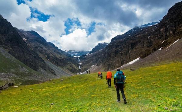
Our trek starts today. From campsite we take wide trail and cross the Rupin for the first time. (Hence onward we will cross Rupin on few occasions till the base of the Waterfall) . After crossing the bridge Rupin stays for the day on our right side. The walk is gentle along the river valley with very low gradient. Rupin runs in the gorge some 500 ft below. One moderate climb of 30 mins takes us to the village of Datadhar. Then we traverse and encircle the mountains for couple of hours gently along Rupin to reach the village of Sewa (~ 2000m, 6550ft). The village is a small one with a tea shop and a small lodge. Wooden crafted temple in the village depicts the influence of Kinnaur culture. The Distance is 10 Km and may take up to 6 hours. There is a nice camping ground just another kilometer after the village on the bank of Rupin. After crossing a short jungle stretch we descent to the river bed and cross a side stream called Aligad. The bridge marks the boundary of Uttarakhand and Himachal. The campsite of Aligad (~ 1900m/6230 ft) is on the true right of Rupin in the state of Himachal Pradesh. It may take up to 6 ours.
- Day 3: Trek to Jhaka – 12 Km – 6/7 hours
From campsite we take the trail along the river and then a steady comfortable climb to hit a motor road under construction inside Himachal Pradesh. This area is under Shimla district and the motor able road on the left goes to Rohru over Changshil top. We take the wide and leveled road on our right along the Rupin to walk around an hour to get a diversion on the road. Our road is on the left towards Gosangu. Another 3 or so kilometers walking on almost flat surface and then a climb of around 500 ft takes us to the first house of the village Jiskun. A tea and noodles shop welcomes the trekkers. Skirting the entire village we cross the last stretch (marked by a cozy lodge apple orchards) and descent inside the jungle to cross a over bridge. This is a good spot to have our packed lunch. From now onward a steady climb takes us suddenly to a turn from where Rupin appears deep beneath gorge. The view of the valley is surprisingly beautiful from here and remains green throughout the year. From here we climb for an hour inside the blue pine forest to see the first glimpse of the village Jhaka. The portion of the village seen from here on a steep slope and looks like hanging on the cliff. There are couple of Home-Stays offering bedrolls and food. It may take 6/7 hours. We can either pitch our tents or stay in the Home-stay. It may take 6 to 7 hours to reach lower Jhaka (~ 2650 m/8700 ft).
- Day 4: Jhaka to Udaknal – 6 Km – 4 hours – (May proceed ahead till Buras Kandi (2 hours)
Starting from the camp site at Jhaka, we gradually climb and cross the upper part of the village and enter in to the magnificent conifer forest. Gently we loss altitude while walking through the forest and after an hour we cross the snow bridge on the Rupin river to go to the trail on the other side. We continue our trek on the boulder covered stretch to reach Buras Kandi. This trail is often used by the shepherds for grazing in summer and monsoon. A steep ascent and followed by walking along the river bed takes us to our today’s camp named Suruwas Thach (~ 3400m, 11150ft). Distance is 7 Km and may take 5 hours. Camp for the night.
- Day 5: Trek to Dhanderas Thatch (Lower Waterfall) – 6 Km – 4 hours
Today we walk on almost level ground and amidst the meadows while we can see numerous cascading waterfalls feeding Rupin. The trail goes through the lash green pastures to our campsite at Dhanderas Thach/Lower waterfall camp (~3550m, 11650ft). Distance is 6 Km and takes up to 4 hours. Camp over night.
- Day 6: Trek to Rati Pheri (camp before pass) – 5 Km – 4/5 hours
A small day’s trek will give us a much needed recuperation on high altitude before crossing the pass. Trail nature differs based upon the time you choose to trek. In the beginning of summer the trail is filled up with ice fields and semi hard frosty snow while in the later half after the monsoon there is hardly any snow. From the base of the water fall the ascend is steep till we reach the top. called Rati Pheri/Upper waterfall camp (~4000m, 13100ft). Distance is 3 Km and may take 2/3 hours. Camp for the night.
- Day 7: Trek to Ronti Gad over Rupin Pass (camp after pass) – 8 Km – 7/8 hours
We start early in the morning to cross the pass. From Rati Pheri the climb is steep and demanding. After an hour or so we reach the vast stretch of snow field and locate the pass above on the ridge line. We climb up slowly as the oxygen level depletes. The exhilarating climb ends at Rupin Pass (~4650m, 15200ft) and the view is mesmerising. This eternally snowbound pass puts up the snowy mountains of Kinnaur Kailash range on the northern side while the Rupin valley in the south. Spending around half an hour we startthe steep descend towards Sangla side. Again depending on the season the level of snow will be determined. After crossing the snowline the descent is sharper till we reach Ronti Gad at the starting of the green meadows (~4100m, 13450ft). Distance is 12 Km and may take 10/11 hours. We camp for the night.
- Day 8: Trek to Sangla via Sangla Kanda – 10 Km – 5/6 hours
Today is our last day of trek and we start in the morning to descend to the Baspa river valley. The height loss is rapid till we reach Sangla Kanda. This is a meadow and has a small lake.There are small settlements of the villagers for summer and monsoon season. Number of trails cutting across the meadow but eventually leading to the main trail. We go down further to enter in to the tree line again and finally to the village of Sangla. There is a bridge to cross the Baspa river and climb up to the motor able road at Sangla (~2700m, 8850ft). Trek ends here. Distance is 12 Km and may take 6 hours.
BANK DETAILS FOR PAYMENT:
| BANK NAME | UCO Bank |
| ACCOUNT NAME | Shimla Online Travels |
| ACCOUNT NO. | 09810210002223 |
| IFSC NO. | UCBA0000981 |
Package include:
• 8 days stress buster from professional life restricted in 4 walls.
• Local Transportation from Dehradun to Daula & from Sangla to Shimla
• Accommodation in Hotels, Tent- Double/Triple sharing bases.
• Food & snacks while Trekking(3 meals a day)
Package Excludes:-
Everything which is not included in the Package.